


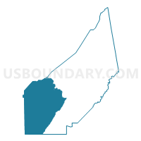
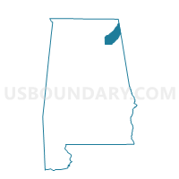
District Two, DeKalb County, Alabama
About
Outline

Summary
| Unique Area Identifier | 521678 |
| Name | District Two |
| County | DeKalb County |
| State | Alabama |
| Area (square miles) | 212.48 |
| Land Area (square miles) | 212.34 |
| Water Area (square miles) | 0.14 |
| % of Land Area | 99.93 |
| % of Water Area | 0.07 |
| Latitude of the Internal Point | 34.34816530 |
| Longtitude of the Internal Point | -86.00127730 |
Maps

Graphs
Select a template below for downloading or customizing gragh for District Two, DeKalb County, Alabama


Neighbors
Neighoring Voting District (by Name) Neighboring Voting District on the Map
- Asbury Fire Dept, Marshall County, AL
- Boaz Rec Center, Marshall County, AL
- Boaz Rec Center, Marshall County, AL
- Childress Store, Marshall County, AL
- Dist. 3 Maintenance Shop, Etowah County, AL
- Dist. 4 County Shop, Marshall County, AL
- District Four, DeKalb County, AL
- District Three, DeKalb County, AL
- Duck Springs School, Etowah County, AL
- Macedonia School, Jackson County, AL
- Sardis City Hall, Etowah County, AL
- Wakefield Comm Center, Marshall County, AL
Top 10 Neighboring County Subdivision (by Population) Neighboring County Subdivision on the Map
- Albertville-Boaz CCD, Marshall County, AL (37,950)
- Fort Payne CCD, DeKalb County, AL (19,055)
- Mountainboro CCD, Etowah County, AL (9,378)
- Crossville CCD, DeKalb County, AL (8,628)
- Section CCD, Jackson County, AL (7,095)
- Geraldine CCD, DeKalb County, AL (6,393)
- Fyffe CCD, DeKalb County, AL (5,373)
- Collinsville CCD, DeKalb County, AL (4,498)
- Town Creek CCD, Marshall County, AL (2,662)
- Wills Valley CCD, Etowah County, AL (1,721)
Top 10 Neighboring Place (by Population) Neighboring Place on the Map
- Boaz city, AL (9,551)
- Whitesboro CDP, AL (2,138)
- Crossville town, AL (1,862)
- Sardis City town, AL (1,704)
- Fyffe town, AL (1,018)
- Geraldine town, AL (896)
- Lakeview town, AL (143)
Top 10 Neighboring Unified School District (by Population) Neighboring Unified School District on the Map
- Etowah County School District, AL (60,417)
- DeKalb County School District, AL (57,097)
- Marshall County School District, AL (47,197)
- Jackson County School District, AL (38,458)
- Boaz City School District, AL (9,551)
Top 10 Neighboring State Legislative District Lower Chamber (by Population) Neighboring State Legislative District Lower Chamber on the Map
- State House District 26, AL (52,448)
- State House District 24, AL (48,127)
- State House District 27, AL (47,288)
- State House District 39, AL (46,905)
- State House District 29, AL (43,353)
- State House District 23, AL (43,186)
Top 10 Neighboring State Legislative District Upper Chamber (by Population) Neighboring State Legislative District Upper Chamber on the Map
- State Senate District 9, AL (144,554)
- State Senate District 8, AL (142,128)
- State Senate District 10, AL (125,075)
Top 10 Neighboring 111th Congressional District (by Population) Neighboring 111th Congressional District on the Map
Top 10 Neighboring Census Tract (by Population) Neighboring Census Tract on the Map
- Census Tract 9607, DeKalb County, AL (8,628)
- Census Tract 308.02, Marshall County, AL (7,726)
- Census Tract 9511, Jackson County, AL (7,095)
- Census Tract 9606, DeKalb County, AL (6,393)
- Census Tract 9605, DeKalb County, AL (5,373)
- Census Tract 312, Marshall County, AL (5,354)
- Census Tract 308.01, Marshall County, AL (5,014)
- Census Tract 110.01, Etowah County, AL (4,613)
- Census Tract 9608, DeKalb County, AL (4,498)
- Census Tract 9609, DeKalb County, AL (3,809)
Top 10 Neighboring 5-Digit ZIP Code Tabulation Area (by Population) Neighboring 5-Digit ZIP Code Tabulation Area on the Map
- 35957, AL (15,693)
- 35951, AL (13,098)
- 35954, AL (12,416)
- 35956, AL (8,842)
- 35962, AL (8,300)
- 35986, AL (7,744)
- 35961, AL (6,514)
- 35971, AL (4,914)
- 35771, AL (3,645)
- 35963, AL (1,704)